Environment and Biodiversity
Place
Hautes-Alpes, France
Sponsor
Gérard Delia
Grant
7,000 € to the Selection Committee at 2008/12/02
Project leader
Adelha
« The irrigation canals offer an opportunity to address the issues of managing the water resources, specific to this mountain environment of the Hautes-Alpes. These canals, which have been vitally important features of the Hautes-Alpes for centuries, provide an illustration of the power relationships and often crystallize a good portion of the customary conflicts associated with this resource. This grant will enable us to participate in a project in which the citizens will address the challenges, at the scale of a geographic and human territory. »
Gérard Delia
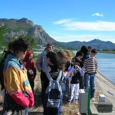
In the Hautes-Alpes district, the irrigation canals play a vital role in the rural, agricultural, human and urban organization of the various valleys. For centuries, they have been supplying and distributing water from the high valleys to the cities. The canal that draws its water from the Drac and conveys it to Gap, for example, supplies 70% of the drinking water needs of the city.
In the highlands, the canals are generally administered, maintained and operated by associations of landlords whose land is crossed and irrigated by these canals. Very often, these landlords are farmers, and this regularly generates tensions between the rural world and the urban world. During the severe summer droughts, in fact, when water becomes scarce, the farmers are often accused of drawing too much of this precious resource for their crops.
Settling conflicts
Adelha, (Fédération Départementale des Hautes-Alpes de la Ligue de l'Enseignement), which is thoroughly familiar with the history of the territories in the Hautes-Alpes, realized many years ago that the canal issue crystallized a major portion of the usual conflicts associated with the water resource of the district.
A popular education movement whose aims include "constructing a fairer, freer and more friendly society", it conducts many projects in education and sustainable development in the region.
Faced with the persistence of these problems, it decided that a thorough knowledge of its canals and of their histories, accessible and shared by all, would help pacify relations between the various users and facilitate understanding and cooperation between all parties. It accordingly decided to create a GIS (Geographic Information System) with all the data collected on the canals. Photographs to identify the ancient routes of abandoned canals, figures on canals in operation, meetings of all the local players - this GIS will be consultable by the public on an Internet site. And the information gathered will provide a basis for drafting a document and producing teaching modules that will provide a medium for major public exhibitions.
This approach is designed to explain the problematics of drinking water management in mountain areas and to pacify relations between the various users, and the Veolia foundation enthusiastically supports it.

